Mount Fisher is a striking peak in Southeast BC, located near the town of Fort Steele. Referred to by locals as “Fisher Peak”, the summit elevation is 2843 m which cranbrooktourism.com says makes it the highest summit in the Southern Rockies (which doesn’t sound right to me, Mount Blakiston in Waterton is 2910 m). What’s undeniable is that it is a formidable looking mountain. Seen from the highway, its stark triangular shape is intimidating. However, there is a scrambling route to the top. Kane and Nugara’s scrambling books don’t cover this area of the rockies, but Joey Ambrosi does include Mount Fisher in his Southern Rockies Trail Guide. In his words, “Views from the summit of Mount Fisher are astounding.” The trip is also described by Janice Strong in Mountain Footsteps 4th ed.
Access is via a Forestry Service Road. Some sections are in pretty rough shape. A high-clearance vehicle with robust tires is a necessity. We were able to navigate based on instructions from Cranbrook Tourism.
I superimposed the driving instructions onto a Google Earth image. Click for a higher resolution zoomable image.
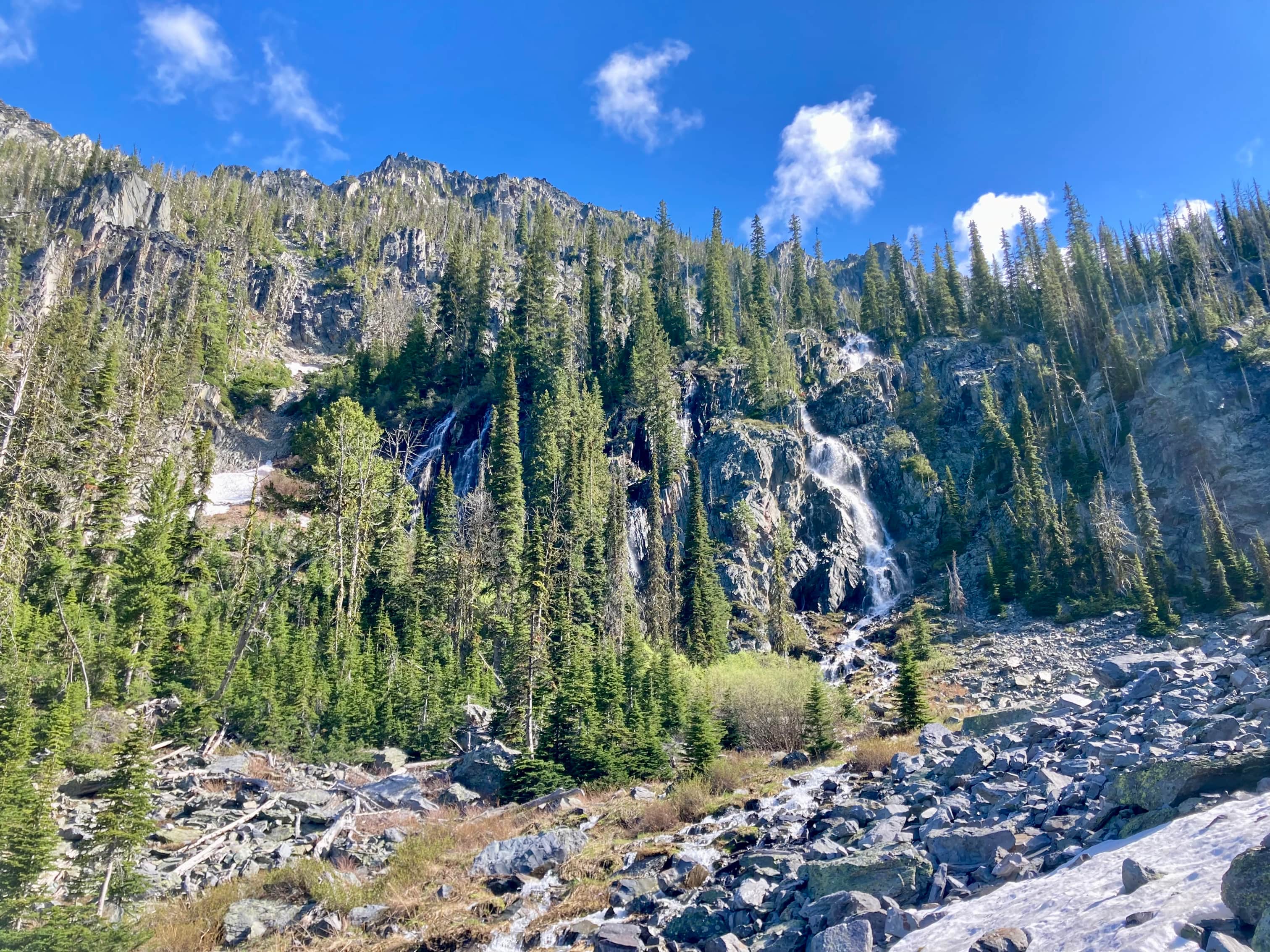
From the trailhead, we began a steep ascent through the woods. A kiosk is present a short distance up the trail with pictures pointing out key navigation spots along the route. The path was pretty obvious and we just had to go over or around a couple of fallen trees. Soon the path came alongside a creek cascading down from the valley above. We climbed along the right-hand side of the creek and eventually encountered the spot where it emerged from beneath a large rockfall. Crossing over the rocks it was fascinating to listen to the creek gurgling unseen beneath us.
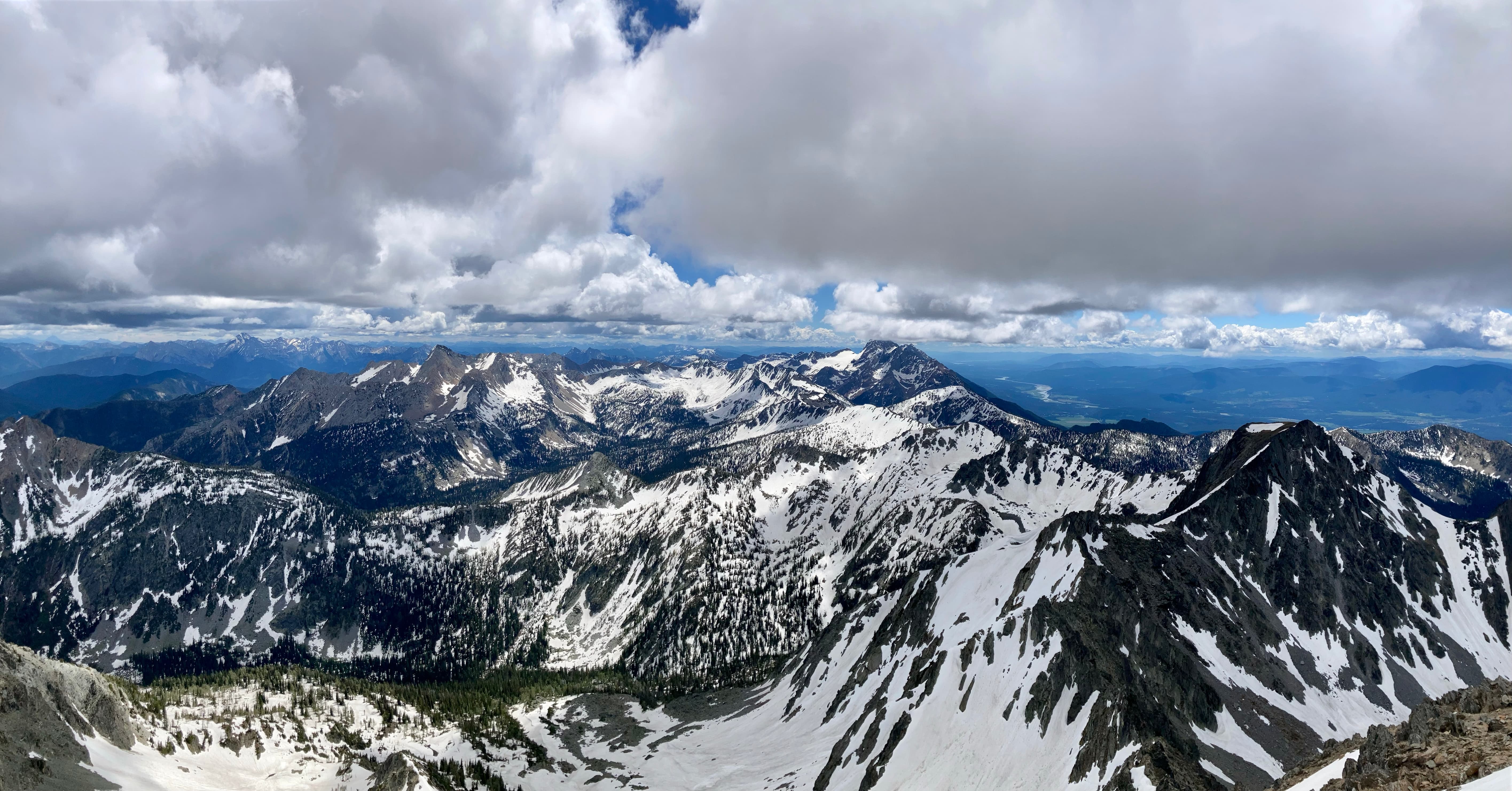
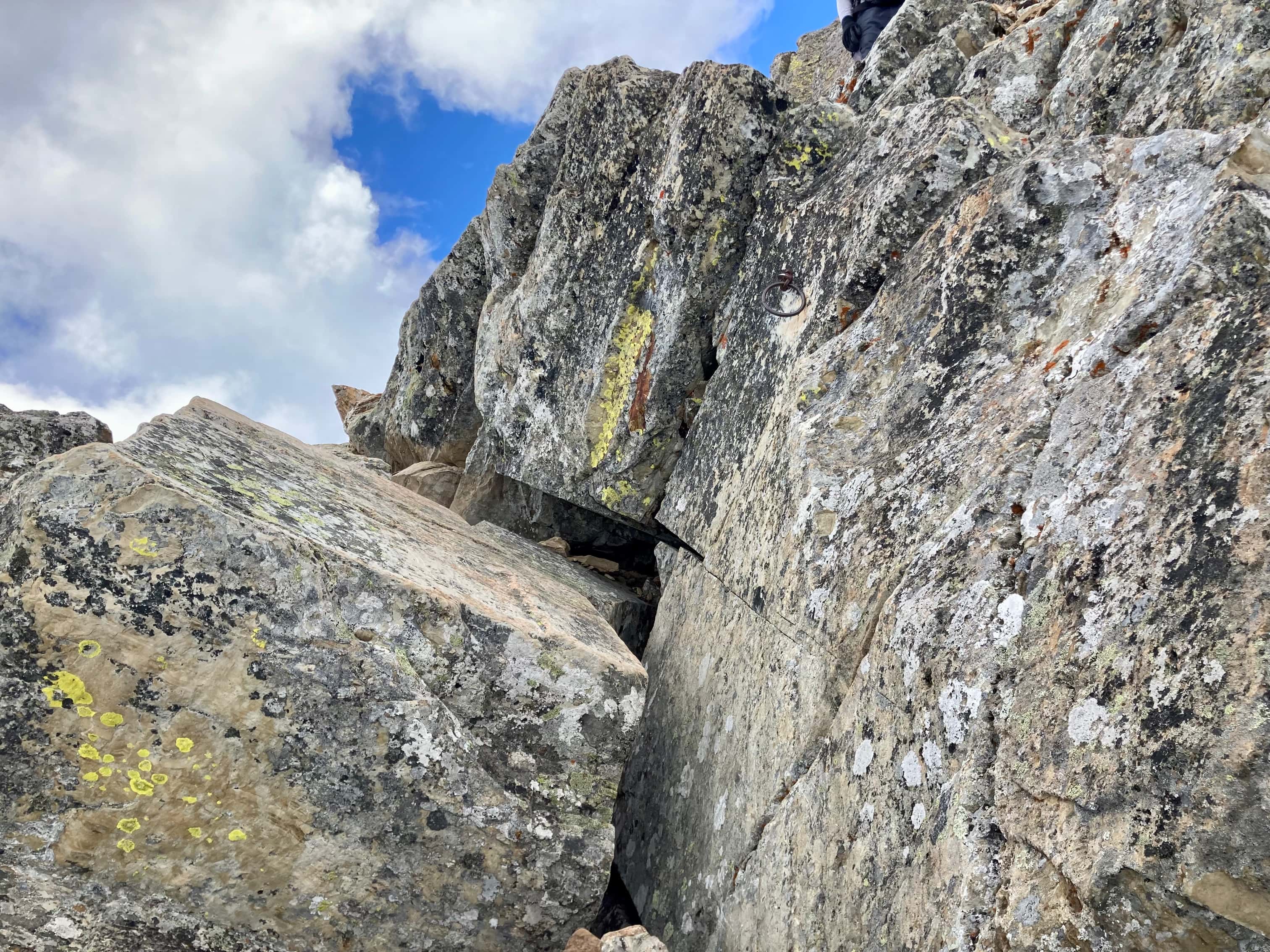
The trail briefly levelled out as we moved onto the rockfall. There were cairns guiding us in the right general direction. A headwall with a cluster of small waterfalls coming down it came into view and we cut left into the woods, finding the trail and following it as it ascended above the waterfalls. We then came out into the elongated valley leading to the cirque beneath Mount Fisher and the connecting ridge between it and an unnamed southern outlier. We were able to identify the “notch” in the col which was the next objective for the ascent. We crossed some residual snow and started sharply uphill towards the col. Once at the col we turned left and followed cairns and a few bolted-on signs. Initially the route doesn’t go directly up the ridge but deviates slightly east (right) before swinging back for the last part of the ascent. After ascending the crux, marked by a bolt and ring, we were soon on the summit.
There was one solo trail runner and one group of two also on the mountain that day. The were moving faster than us and somewhat amusingly all three groups converged right at the crux, causing a miniature “Hillary Step” type traffic jam. The trail runner was a frequent visitor to the peak. The group of two were visiting from Calgary and Japan. One of them set up an interesting antenna for the purposes of a radio broadcast. This was something new for me, and the hiker explained that this was something called Summits on the Air. This article explains it a bit more.
After enjoying the summit views we made our way back to the col for a long break and some food. We took another long break down in the valley before heading back to the access road.
Click on the pictures in the gallery below to access higher resolution images.
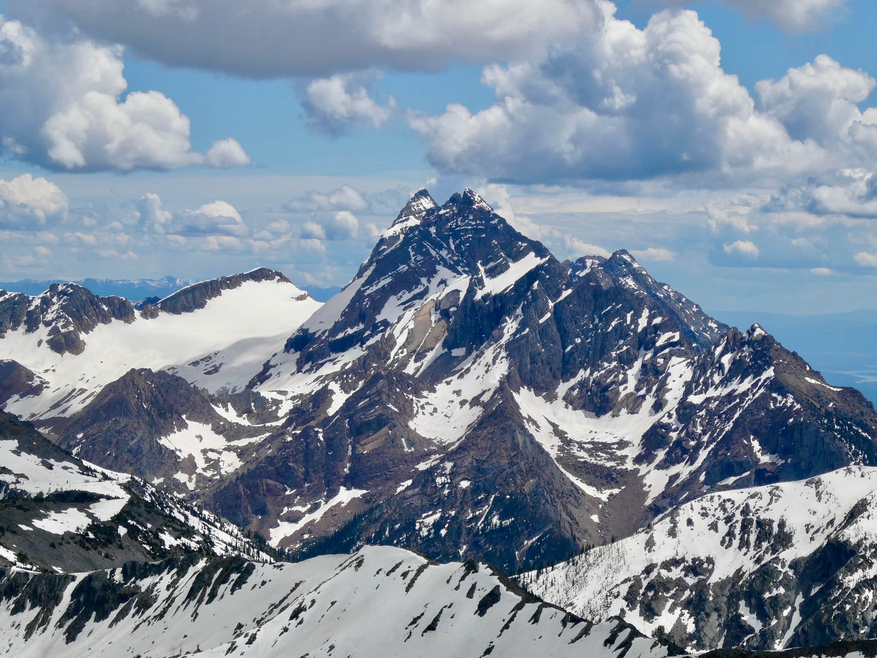
Route overviewMount Fisher as seen from Hwy 3.A closer look at the peak.Sign on Mause Creek Road at the Y-intersection beyond which the road gets much more rough.The sign at the trailhead. The kiosk with the route instructions is a short distance up the trail.After some steep climbing through the trees the trail comes alongside this creek cascading down to the valley bottom.The spot where the creek emerges from beneath a large area of rock fall.The waterfalls. The route cuts sharply left here over the creek and into the trees before ascending above the level of the falls.Above the falls and back alongside the creek. Mount Fisher’s summit finally comes into view.The impressive rocky face of the southern wall of the valley. A crystal clear tarn sat in this part of the valley, feeding the creek.A second tarn a little further up in the valley. The “notch” in the col we aimed to ascend to is visible left of centre where the darker rocks meet the lighter rocks.A closer look at the notch.Coming up on some snow patches. The notch is quite apparent now. We went beyond the treed dark rocks and ascended a gully below the notch.More of the south wall of the valley.Looking up the ascent gully. Definite rock fall hazard here. We stayed right and avoided most of the loose rock.Looking back from part way up. Note the track in the snow leading to a sizeable boulder down at the valley bottom. The track was fairly fresh – that boulder spontaneously fell just a short time earlier. A party of two climbers is visible a short distance down the valley.A distinct pinnacle on the ridge across the valley.Looking back at increasingly impressive views.Sunlight on the far wall of the valley.The last bit of scrambling up to the col.The first glimpse of terrain on the other side of the col. I believe that is Mount Patmore.Looking back to the west towards the Kootenay River and the Rocky Mountain Trench.Looking up towards the summit. The route doesn’t head straight for it. Rather, it first bears to the right slightly. There were markers fixed to boulders along the way to help with route finding as well as various cairns.Ascending. One of the yellow and black markers is visible on a boulder in this picture, but you’ll need to click for the higher resolution image and zoom in to see it.Taking a break and looking south at Mount Patmore and The Steeples.Nearing the crux.The crux. It’s marked by a bolt and ring.Immediately above the crux. There’s some exposure to the left.Quite the drop-off to the left. Not so long before this we were looking up at the impressive rocky face across the valley.Very soon after the crux we reached the summit of Mount Fisher.Me, demonstrating poor posture on the summit. Photo courtesy of Bhaskar Bhowmik.Panorama looking west. Mount Fisher is next to the Rocky Mountain Trench. Cranbrook is in the distance. On there horizon is the Purcell Mountain Range, part of the Columbia Mountains.A closer look at the Purcells.Panorama looking north. Mount Lum and Nicol Lake are in the foreground to the right of centre. A closer look at Mount Lum and Nicol Lake.Panorama looking east.Crowsnest Mountain, far to the east. More nearby to the east was this distinctive mountain. It doesn’t have a name I can find.Mount Frayn and Mount Terrion.Mount Washburn, I think.Panorama looking south. The Steeples, left of centre, drew our eyes most of the time we were on the summit.The Steeples.A closer look at The Steeples.And an even closer look.Mount PatmoreDescending. Now back to the level of the col.The Steeples were still capturing my attention.Back down into the valley.Walking out.


One thought on “Mount Fisher”