June 11, 2021. A bike & scramble featuring some great views but also some prolonged hiking off-trail in dense forest.
- Region: Castle Wilderness. Traditional territory of the Tssu T’ina, Ktunaxa, and Blackfoot First Nations
- Distance: 20.5 km round-trip
- Total Ascent: 1500 m (the route involves some gain/loss/gain of altitude)
- Elevation of Objective: 2453 m
- Time: 7h 18m
- Safety and Disclaimer
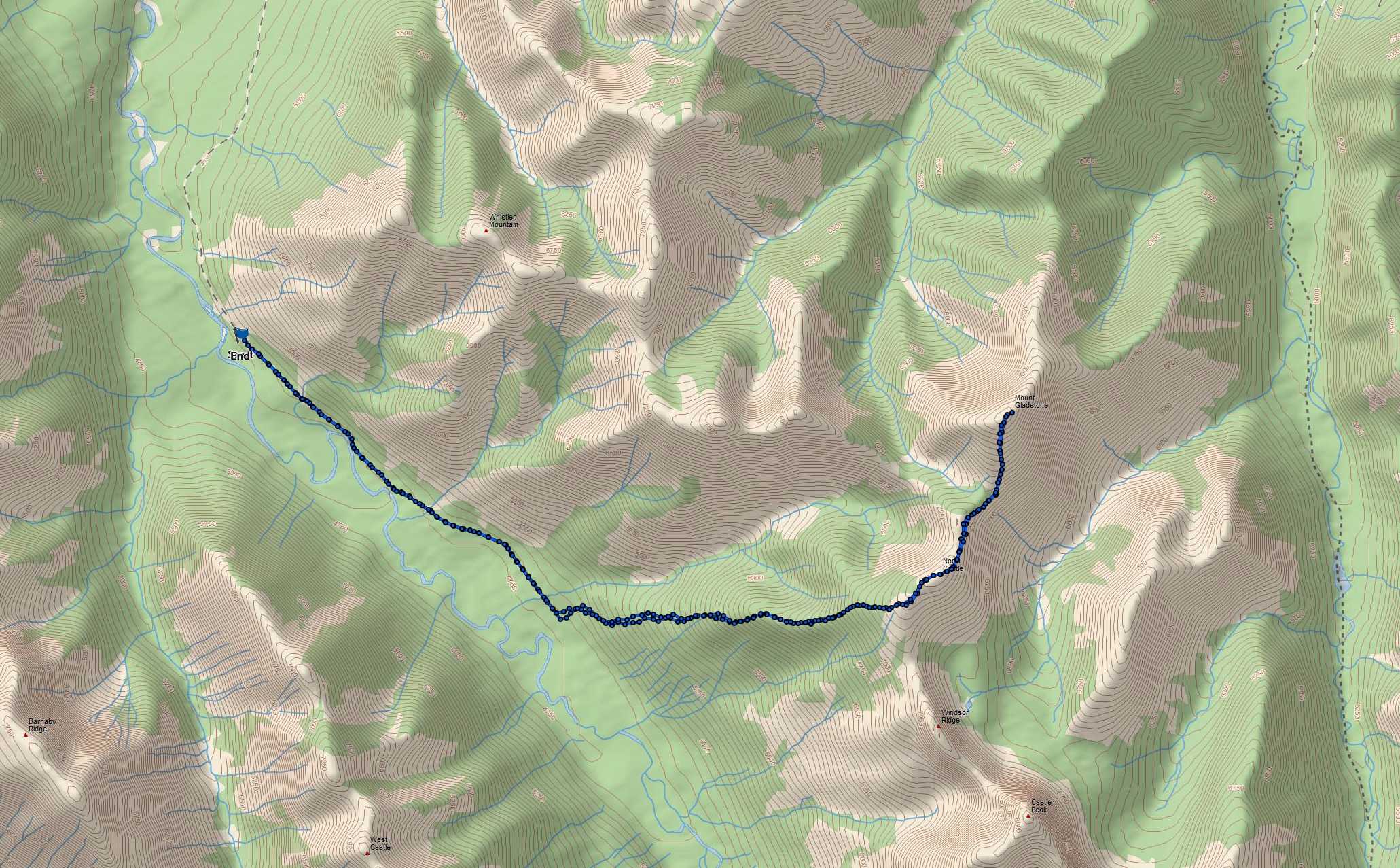
Mount Gladstone sits adjacent to the very picturesque Castle Peak and Windsor Mountain in the Castle Wilderness. The most frequently described scrambling route to the summit approaches from the east and ascends the southern aspect. This route appears in Nugara’s More Scrambles in the Canadian Rockies 3rd ed. Gladstone was on my list of objectives, but I decided to come at it from the other direction – from the west, first biking roughly 4 km along the South Castle Road, then ascending a wooded peak called North Castle, then following the connecting ridge to Mount Gladstone.
My reasoning was twofold: I could tag two summits this way, and I would also have the chance to explore a little further along the South Castle Road to see if it was bikeable. The South Castle Road is a rough and rutted backroad that is blockaded beyond a parking area near the start of the Whistler Mountain trail. I have a goal of eventually climbing Castle Peak and Windsor Mountain and the start of that trip would involve hiking or biking several kilometres past the vehicle blockade at the parking area. Thus, using the western approach to Mount Gladstone would allow me to scout the road and see if it was feasible to bike it.
I had a GPS track on the TopoMaps Canada app that would serve as a guide. This was essential during the initial portions of the climb which goes through dense forest. I referenced trip reports from Sonny Bou, Bob Spirko, and Dave McMurray to prepare. Bou mentioned that when he went up this way with Spirko they used a GPS to stay on-route so I didn’t feel like too much of a cheater. The trip reports that I referenced all dated from before the road was blockaded near the Whistler Mountain Trail – they were able to use 4×4’s to drive almost all they way to the start of the ascent.
Access is the same as for Whistler Mountain. From Pincher Creek take Hwy 507 west, then turn left onto Hwy 774 and pass through the town of Beaver Mines. There will be signs for the Beaver Mines Lake campground at about 14.7 km from the turn. Once on the gravel access road to the campground follow it for about 3.7 km and turn right (south) onto a gravel road. This road soon comes to a creek crossing. If the flow is low enough and you’re confident in your vehicle, it can be driven across. If not, there’s space here to park without blocking anyone else. Beyond the creek crossing is roughly 5.5 km of variable-quality dirt and gravel road. Some stretches were smooth and dry, others were rutted, or pocked with mud puddles of variable depth. I’m fortunate enough to have a Subaru Outback, and managed to drive the road with minimal anxiety. The vehicle-accessible portion of the road ends in a blockade of rocks and concrete barriers. At the blockade there is parking space, a small kiosk, and signs pointing the way to various trails.
I biked about 4 km beyond the barricade. The quality of the road was variable, with some areas too rocky for me to negotiate without walking the bike. There were a few reasonably mild areas of ascent and descent. At about 2.4 km I crossed a broad cutline, then at 4 km I reached a creek which ran across the road in a shallow flow. Just beyond here was the start of the ascent through the forest. One distinguishing feature of the creek marking the start of the ascent was an orange sign fixed to a tree describing information relevant to a Forest Management Project. I stashed my bike and plunged east into the forest.
The initial climb involved negotiating a great deal of deadfall impeding easy or direct movement. I just had to move generally east and make a point of ascending, not just traversing, to try to get to the top of the broad, rounded ridge completely covered with trees. The GPS was very handy here, though it was pointless to try to follow the GPX track too closely because of the deadfall. After a little over 1 km of this I reached the edge of a clearing which was the first of a collection of interconnected clearings that I could follow for about 500 m more until I finally got above the trees. This allowed me to see some views of the surrounding mountains. From here the way to the ridge top was visible and I climbed up the wonderfully clear terrain.
Once on the ridge top I could see the remainder of the ridge as it headed to the treed peak of North Castle. Much of that route was tree-covered, but the trees were not as dense as below, and travel among them wasn’t a problem. Shortly before getting to the summit I deviated south a bit to a clear area that allowed an amazing view of Castle Peak and Windsor Mountain. I then carried on and reached the summit. There was a lot of snow between the trees as I got closer to the summit. I don’t know if there’s a cairn up there under the snow or not. It took me 2h 50m to this point. From North Castle’s summit, the summit of Mount Gladstone and the intervening ridge were in view.
Getting to Mount Gladstone’s summit involved losing about 100 m to get down to the col then climbing about 200 m to the summit. On the way down to the col were 3 rocky steps that had to be down-climbed. The terrain would qualify as moderate scrambling. Beyond the col was just some steep hiking to Gladstone’s summit. I reached the top at 3h 50m. The weather throughout the day had been unsettled. Passing bands of clouds would periodically obscure adjacent peaks, rain and ice pellets fell from time-to-time, and the wind was strong enough to almost push me over. Thus, my stay on the summit was pretty short. I retreated to the col and sheltered behind some trees to eat lunch and enjoy the views of Castle Peak.
I returned the same way with no difficulties aside from falling off my bike when I tried to bike through a rocky area that I shouldn’t have. Overall, this was a bit of a tough day and I can’t recommend this as a good route to the top of Gladstone. I’m sure I’ll eventually try out the usual southeastern approach. However, I did establish that the South Castle Road is something I could bike, provided I’m careful.
Click on the pictures in the gallery below to access full resolution images.


