Festubert Mountain isn’t a tough scramble, but it’s located in a fairly remote part of Waterton, so a trip to climb it makes for a long day out. We decided to approach it via a long ridge walk from Mount Rowe.
Access is the via the Rowe Lakes trailhead on the Akamina Parkway. We followed the excellent trail past Lower Rowe Lake, to Rowe Meadow, then up to Upper Rowe Lakes. Last time I climbed Mount Rowe I ascended the northeast ridge. This time we took the less scrambley route up the steep hillside to the right of the lakes and followed it to the ridge northwest of the summit. Our direct access to the ridge was blocked by a steep snow patch that had to be circumvented. Once up on the ridge we headed southeast and tagged the summit of Mount Rowe. After enjoying great views of the Cameron Lake area we set out on our long ridge walk to Festubert Mountain.
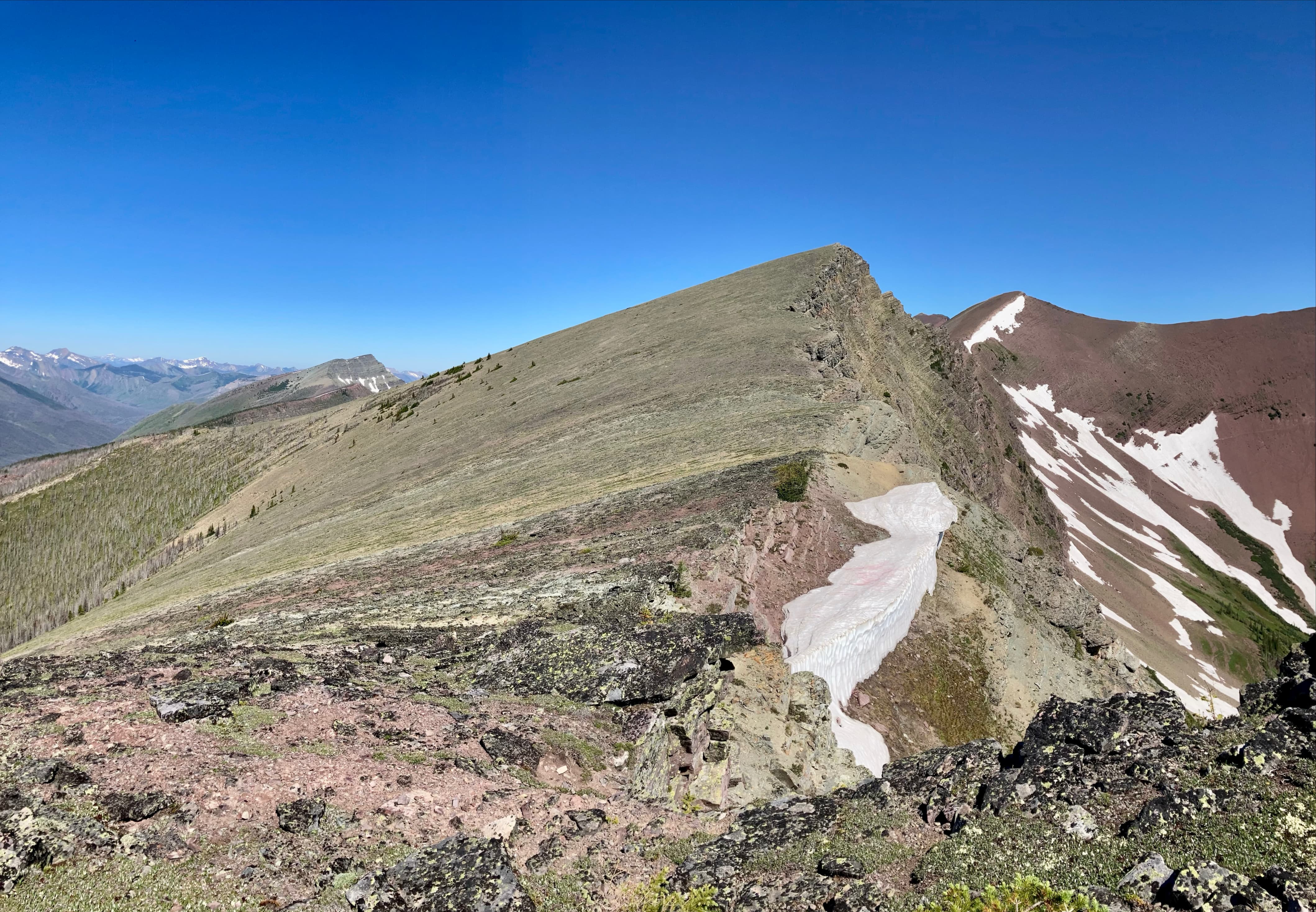
The route was obvious, proceeding northwest towards two nearby high points then onward to distant Festubert Mountain. These two high points are actually a little higher than the summit of Mount Rowe. We tagged the first one, which boasts a fairly large cairn. We then carried on towards the 2nd high point. On our outward journey we bypassed it to the south, but we tagged it on the way back. Beyond the 2nd high point we could see Festubert Mountain, still a long way off. We carried on along the ridge, walking at the top of a vast rock wall that forms part of the western edge of Waterton Lakes National Park. The terrain along the ridge was quite uneven and covered with large rocks. Luckily, we found a pretty good animal trail which allowed for easier travel. It mostly stayed immediately adjacent to the drop-off next to the ridge. Conditions were dry and there was no snow on this part of the route, so there were no safety concerns. In less ideal circumstances I think I’d want to stay further away from the drop-off.
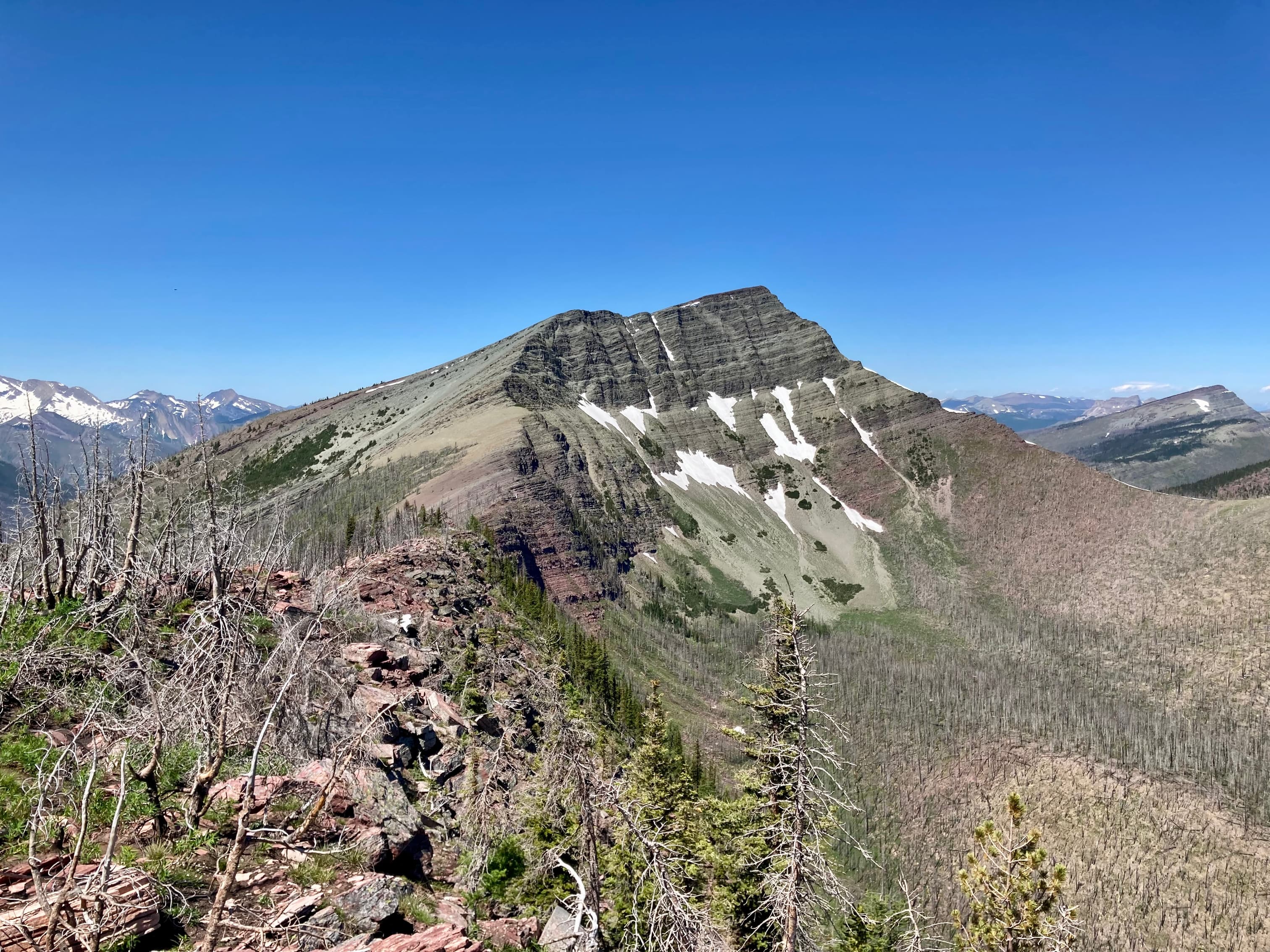
Once we were nearly to Festubert there was a 3rd high point to climb and descend. Then we could finally tackle our objective. We followed the ridge up to the summit. There was no tricky route-finding and the limited scrambling was of moderate difficulty without any big exposure. We reached the summit 6 hours 45 minutes after setting out. While we rested at the summit we were joined by a backcountry camper and her lovely dog Shadow.
For our return trip we had the option of dropping down into the valley south of the summit and following the trail at the valley bottom back to Akamina Parkway, or simply retracing our steps. I had read Nugara’s blog post for this trip before setting out. He took the route south into the valley for his return trip and the words “nasty bush whacking” and “mind-numbing 12 km hike” stood out in my memory. We decided to go back the way we came, having to re-climb the high points but staying where we could enjoy the views.
Click on the pictures in the gallery below to access higher-resolution images.
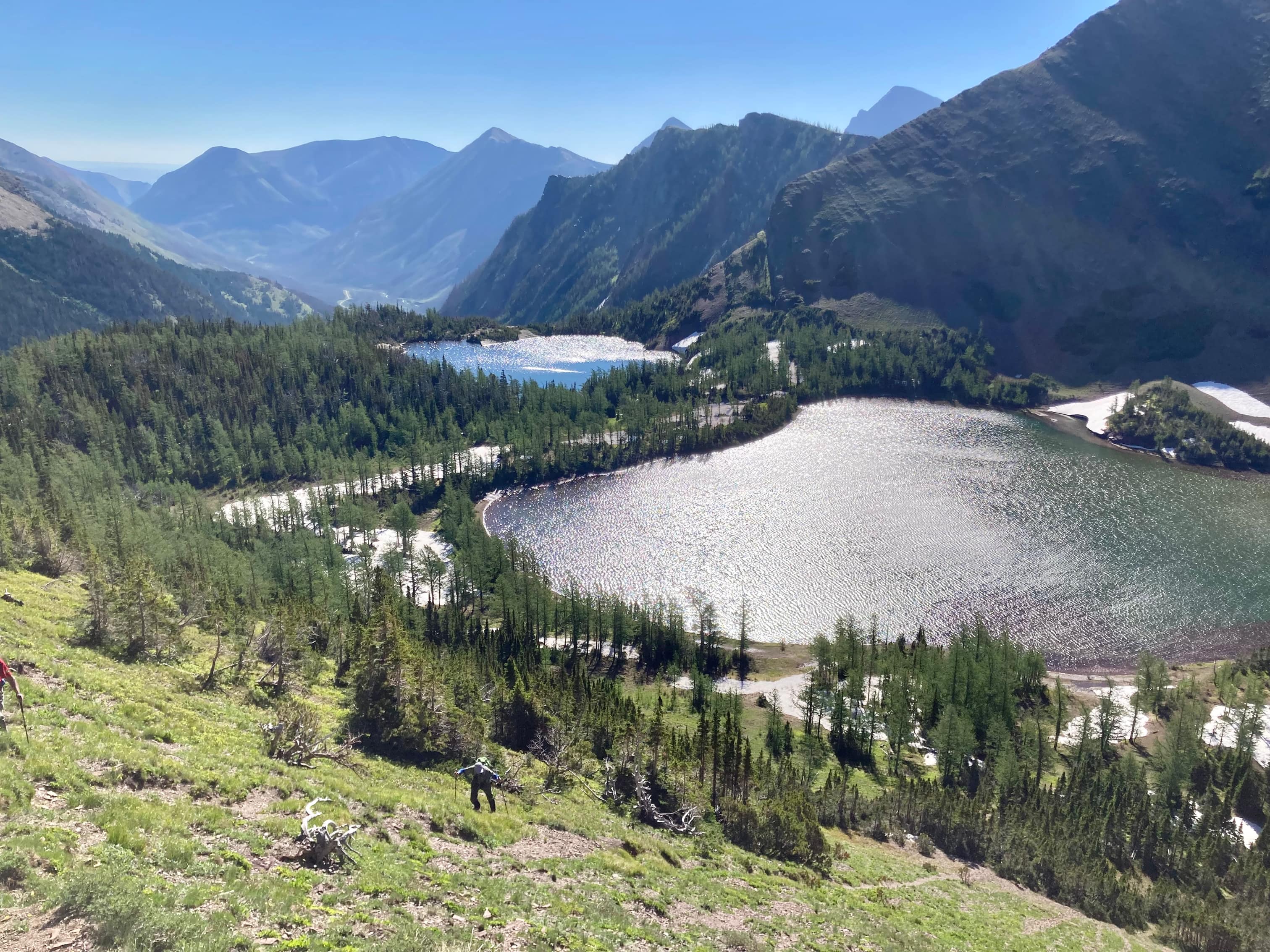
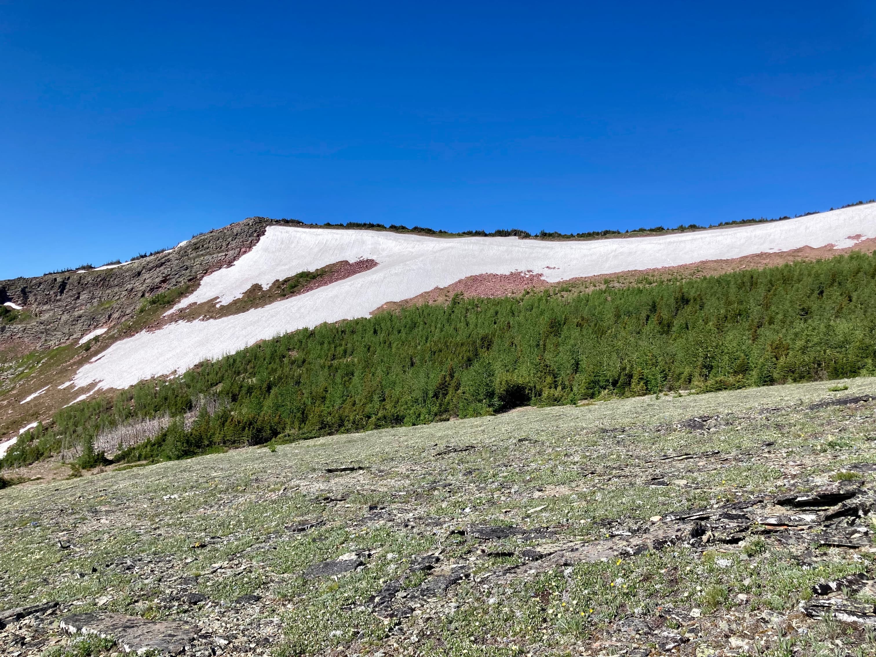
Route overview looking northWe started off by following the official trails to the Upper Rowe Lakes. Mount Rowe’s summit is a little left of centre in this picture. Last time I was here I went up the ridge on the left, which involve some hands-on scrambling. This time we ascended the steep hill on the right to reach the summit ridge.Looking back at the two Upper Rowe Lakes.Once up on the hill, we navigated through this little larch forest. A big snow patch stood in the way of our direct ascent to the ridge.As we got closer it became clear that the snow would represent an actual barrier. It was steep and firm. Someone or something had descended at some point, but tentative steps upwards led to sliding back down. The runout terrain below the snow wasn’t too friendly so we went around to the right.The snow thinned out just as we got to some cliffs, so that was lucky.Taking a look down from that point. Rowe Meadow is far below. Mount Lineham is across the valley and the top of Aahkoinimaiisták/Mount Blakiston is visible beyond.Above the snow, looking towards Mount Rowe’s summit.The summit of Mount Rowe. Climbing it this way was very straightforward, but not as much fun as scrambling the northeast ridge.Looking south from Mount Rowe. Four lakes are visible: Akamina Lake, Cameron Lake, Forum Lake, and Wall Lake. Mount Chapman and Mount Custer are beyond Cameron Lake on the left. Forum Peak and Akamina Ridge are on the right.Looks like it was shaping up to be a great day at Cameron Lake.Chapman PeakMount Custer and Forum PeakForum LakeWall Lake, with Akamina Ridge above itLong Knife Peak. The first of many pictures I’d take of the mountain.Looking north from Mount Rowe. The Upper Rowe Lakes sit in their hanging valley. Lineham Ridge and Mount Lineham are across the valley. The first two high points we’d encounter along the ridgewalk to Festubert are the first two high points in the mid-ground on the left. Festubert’s summit is in the far distance between them.A closer look at Festubert Mountain.From Rowe’ summit, we set out along the ridge toward the 1st high point. The terrain here was strewn with rubble and small boulders which made for slower travel. The entire route from Mount Rowe to Festubert Mountain followed the Continental Divide. British Columbia was to the left and Alberta to the right.The cairn at the summit of the 1st high point.Looking northeast from the first high point. The switchback trail to Upper Rowe Lakes is visible at the lower right. From left to right: the 2nd high point, Lineham Ridge, Mount Hawkins, Aahkoinimaiisták/Mount Blakiston, and Mount LinehamCarrying on towards the 2nd high point. In the distance, Festubert Mountain is now clearly in view.Heading down from the 1st high point, enjoying the views of Long Knife Peak.At the col between the first two high points.We decided to bypass the 2nd high point on the friendly slopes to the left, figuring we’d tag it on our way back if we had energy.Beyond the 2nd high point we were treated to this amazing view. The vast rock wall on the left forms the western border of Waterton Lakes National Park. Descending from Lineham Ridge on the right is the Tamarack trail. Festubert Mountain is left of centre. There’s something of an optical illusion at work here, which has been noted by others. It seems that Festubert is closer than it actually is. I think this has to do with the large scale of visible terrain and the lack of significant landmarks along the ridge between here and the mountain to give a sense of distance.Starting our walk along the top of the huge rock wall. At first we ended up among boulders and trees which made for slow going. Eventually we found that there was a good animal trail that hugged the edge of the cliffs.The cliffs below the 2nd high point.Some of the more tame terrain rocky terrain. The recent fires burned away a lot of the vegetation on this part of the ridge so bushwhacking was minimal. Up ahead things got more rough before we found the animal trail. The red-topped 3rd high point is visible further along the ridge.Navigating some interesting terrain.We finally found the smooth trail along the edge of the cliffs.As we continued, the peaks of the Baurman/Lost/Anderson massif came into view.Ascending now to the 3rd high point.The cairn on the 3rd high point.While we had a break at the 3rd high point, I took yet another picture of Long Knife Peak.Almost to Festubert Mountain.The start of our ascent of Festubert. It was mostly steep hiking, but there were a couple of rock bands to scramble up.Part way up.Above the short scrambling section there’s just some straightforward hiking.Looking backThe summit is in sight.Along the route we took, the mountain looked grey-green from a distance. The summit turned out to be red argillite.The summit of Festubert Mountain.Summit panorama looking northeast.Summit panorama looking southwest.Lone Lake, sitting below Lone Mountain on the right. Kishinena Peak is further along the ridge. Mount Matkin in the distance at centre.A bit of a closer look at the lake. There’s a campsite and ranger cabin down there – I assume the visible building is the ranger cabin.Mount MatkinKintla Peak and Long Knife Peak. Long Knife sits more-or-less along the international border, so everything between here and there is in B.C.King Edward Peak and Starvation PeakStarvation Peak again at the left. Miskwasini Peak, Kenow Mountain, and Langermark Mountain are at centre.Commerce PeakCastle PeakAahkoinimaiisták/Mount Blakiston, looking fairly mellow from this viewpoint.Time to head back.It was easy to pick up the trail again.Lots of interesting terrain.Some of us decided to tag the 2nd high point which we’d bypassed on the outward journey. The rest bypassed again.Closing in on the 2nd high point.The cairn on the 2nd high point.Almost back to the 1st high point. From there we descended back to the lakes and followed the trail out.