July 3, 2020. An easy scramble (with some unpleasant bushwhacking) to the summit of Pincher Ridge in the Castle Wilderness, followed by a quick visit to Drywood Falls.
- Region: Castle Wilderness. Traditional territory of the Ktunaxa, Tsuu T’ina, and Blackfoot First Nations
- Distance: 14.7 km round-trip
- Total ascent: 1082 m
- Elevation of objective: 2426 m
- Total Time: 4h 49m
- Safety and Disclaimer

Pincher Ridge is one of the 5 parallel ridge lines in the southern Castle region immediately north of Waterton. The official summit is located on the northeast portion, and there are several routes that can be taken to reach the top. Nugara describes a few in More Scrambles in the Canadian Rockes 3rd ed. The routes he suggests for attaining the summit are rated “difficult; sections of steep, exposed scrambling; route-finding challenges”. This didn’t seem like my cup of tea. Luckily, there’s an easier way up, which Bob Spirko described in a a 2006 blog post. Spirko’s ascent to the summit was followed by a trip along the ridge to the central and southern high-points. I decided instead to just hit the true summit, then descend and check out Drywood Falls, which turned out to be only a short walk from the start of the scrambling route.
The trip starts out by following the official trail to Drywood Falls (more properly North Drywood Falls, but I haven’t heard anybody actually call it that). The trailhead can be found by heading south from Pincher Creek, or north from Waterton, on Hwy 6. Turn west onto the Shell Waterton Complex Road and drive past the complex. Where the road branches, turn left (Forest Reserve sign) – this is Twp Rd 4-3. Follow this about 3.8 km to Butcher Lake. Turn left just before the lake and go straight along the road for 2 km to the locked gate, parking area, and kiosk. Ask Google Maps to drop a pin here: 49.2873555,-114.0653550 and it’ll show you where to go.
The Drywood Falls trail is an old road which is broad and easy to follow. The grade is fairly gentle, and bicycles are allowed, so I decided to bike this portion of the trip. This presented no difficulties, though there was a brisk westerly wind, which made for some tiresome peddling in the morning…but a very easy return trip at the end of the day. About 3.7 km from the trailhead there’s a bit of a clearing and some bigger stones arrayed across the trail. Beyond, the trail dips down and heads to Drywood Falls, only about 500 m away. There’s a single piece of orange flagging on a tree on the north edge of the clearing. Who may have placed it is lost to the mists of time…Spirko saw it in 2006 and Nugara mentions it in his book, too.
I stashed my bike in the woods and tackled the bushwhack which kicks off this scramble. The flagging led to a vague path through the underbrush. At the time of my visit the trail was obscured and obstructed in many places by deadfall. Here and there I was able to see more flagging, but it eventually stopped (or I went too far off track). In any event, the only bit of direction I could give anyone here is that you may eventually come across a bit of a drainage if you bear slightly left as you ascend in the underbrush. You can follow along this until you climb above the patch of trees. Once out of the trees there’s still plenty of shrubbery to contend with, but at least you can see where you’re going.
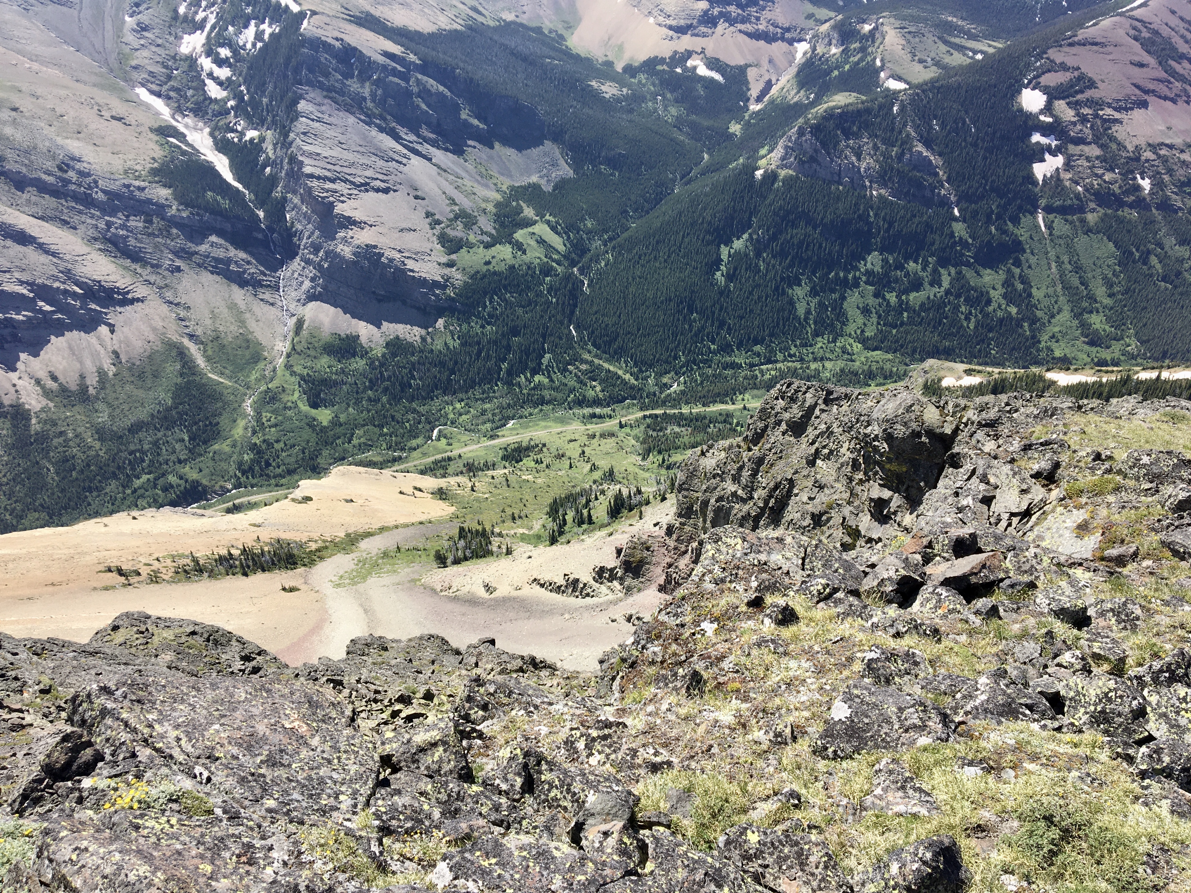
There’s about 500m of this bushwhack. The terrain ascends pretty steadily, and I eventually found myself able to see some rocky black terrain rising ahead. Out of the trees but still in the bushes, I bore left around the outcrop and eventually was out on an open grassy slope, which allowed me to ascend above the rocks. Ahead, there were similar black rocky outcrops, which I navigated in a similar manner until I reached a large slope of yellow scree. The summit still isn’t visible at this point. I bore right to get to an area of more gentle ascent and decent footing. The GPS track I was using as a reference charged straight up the scree…making me wonder if its author only recorded their descent, or if the person was a masochist.
Continuing ascending to the northeast I eventually encountered a clutch of trees on a ridge line ascending northwest. The black rocks of the summit finally came into view at this point, rising on the other side of a wide gully. I followed the ridge northwest, climbing to a minor prominence on the saddle at the top of the gully. The terrain here was intriguing – there was the same yellow stone as the rest of the slope, but several platters of it were arranged in a near-upright orientation. Exactly how this could happen, I’m not sure. They were tilted in the opposite orientation to what I’d expect if it was simply the result of the wind.
From that point, the rest of the route to the summit was obvious. The terrain changed from yellow scree to blocky black rock with scattered moss patches. From the saddle onwards, the views just got better and better. About 2h 20m after setting out I reached the summit. It’s marked with twin cairns and there are dramatic sheer drop-offs in all directions around it except for the gentler ascent slope. I stayed on the summit for a time and ate lunch since the wind had slowed slightly. The view was excellent despite some degree of haze in the air.
I descended back to the yellow rock, then instead of directly retracing my steps continued my descent on the scree. The only word of caution here is that the slope was naturally pulling me to my right as I descended, towards steeper terrain and well off-course to where I wanted to descend back through the black rocks further down the mountain. I made several leftward corrections in my descent, then re-joined my original path and descended the rest of the way to my bike.
To finish the day off, I strolled down the trail to Highwood Falls and enjoyed the ambiance for a time before returning to my bike and riding out.
Click on the pictures in the gallery below to access full-sized images.


Once again looks like you had a great hike with beautiful views.
The Drywood waterfall also looks really nice, including the ridge of the Drywood mountain.
LikeLike
Thanks for reading! Drywood’s on my list to do. Just deciding on a route…
LikeLike
If you have climbing knowledge and experience then I would suggest you would go through the entire ridge.
Reaching the peak of a mountain via a nicely formed ridge is always a great experience.
LikeLiked by 1 person