May 31, 2025. Tagging an unofficial peak neighbouring one of the Crowsnest Pass’s most popular early-season objectives.
- Region: Crowsnest Pass. Traditional Territory of the Blackfoot, Tsuu T’ina and Ktunaxa First Nations
- Distance: 2.2 km round-trip from South Livingstone Peak
- Total Ascent: 240 m due to repeated loss and gain of altitude out-and-back from South Livingstone Peak
- Elevation of Objective: 2204 m
- Total Time: 2h 15m round-trip from South Livingstone Peak
- Safety and Disclaimer

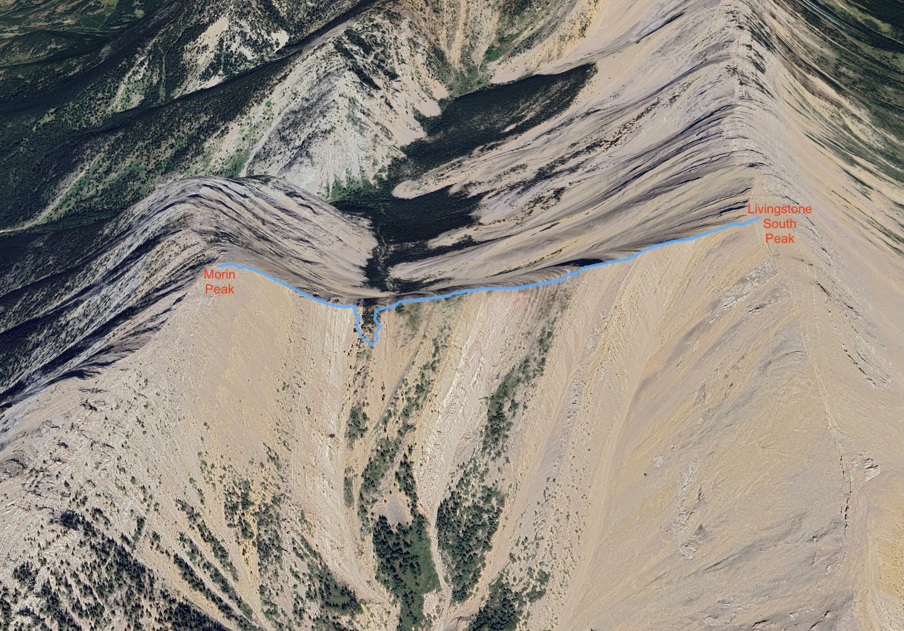
Immediately west of Livingstone South Peak is a slightly lower outlier, unofficially named Morin Peak (a mountain in the Terrace region of British Columbia is the official Morin Peak). On previous trips to the top of Livingstone South I’d looked west and pondered whether to go tag Morin, but never actually went and did it. For the last day of May 2025 I decided to return to Livingstone South Peak with the explicit goal to carry on from there to reach the summit of Morin Peak.
The route isn’t described in any of my books. A number of online sources (see below) describe an ascent from the west which starts in roughly the same place as the trail to the ghost town of Lille. I was a hesitant to approach from that direction since it would involve weaving around some private property. Vern Dewit, however, approached from the east following an ascent of Livingstone South Peak. His trip report discusses how he dealt with the major obstacle in the traverse – a big cliff about 3/4 of the way along the ridge. The cliff is invisible when approaching from the east and directly down climbing it would go well beyond the realm of scrambling. Dewit overcame this obstacle by undertaking a significant descent to circumvent the cliff. In his own words:
I knew I could overcome the obstacle with my “secret weapon” so I wasn’t too concerned about it. What is this mysterious weapon you ask? Simple – it’s my willingness to descend 100’s of meters to avoid failure on a peak.
That might be one of my favourite bits of writing in a hiking blog. Luckily, 100’s of meters of descent wasn’t required. In my research, I also discovered that the route for the Minotaur Skyrace includes a traverse of the ridge connecting Morin Peak and Livingstone South Peak, and their route resembled Dewit’s. This information gave me enough confidence to give it a try.
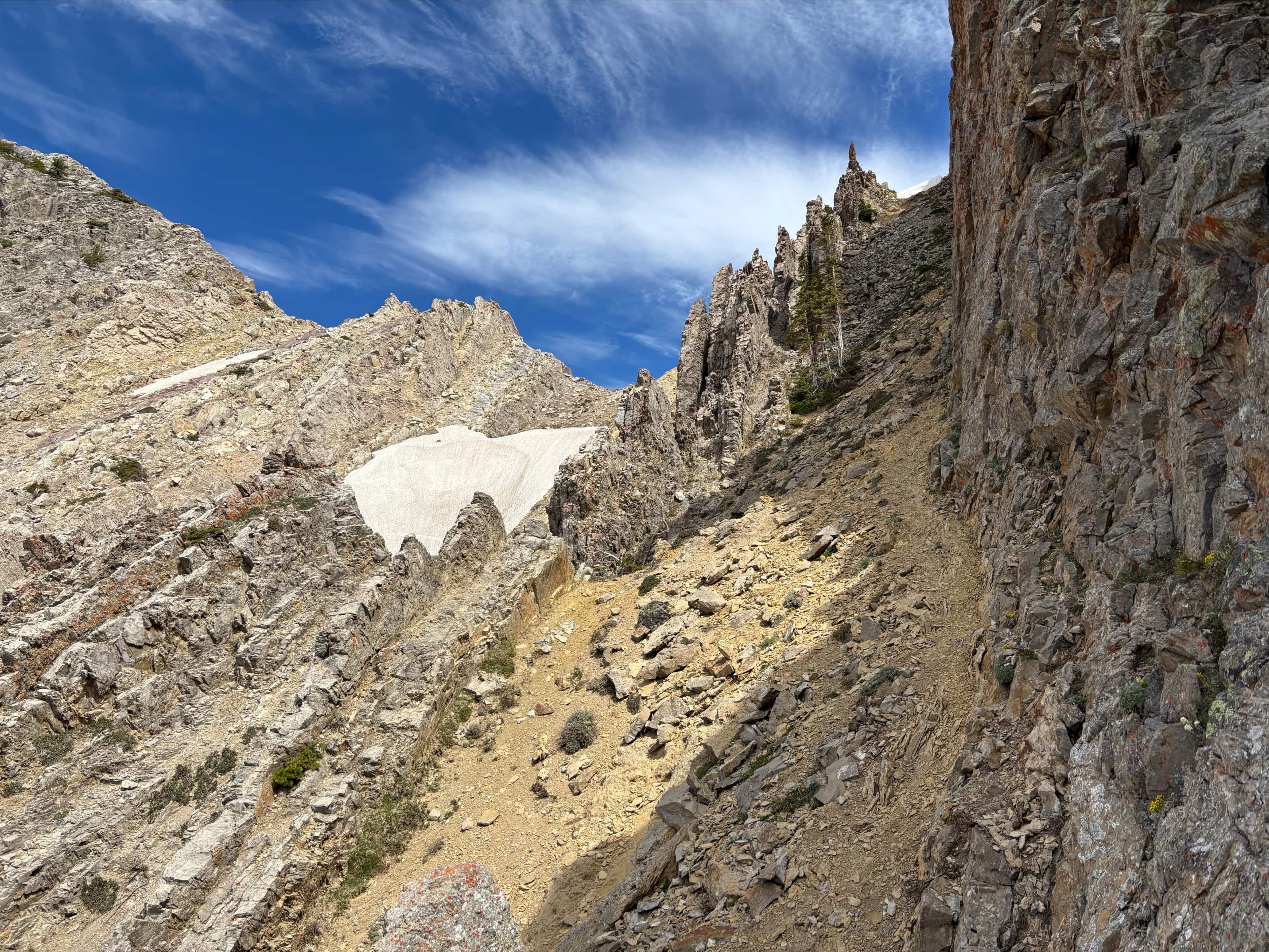
Please refer to my Livingstone South Peak post for a description of trail access and how to reach that summit. To get to Morin Peak, I climbed South Livingstone then I set out due west, descending some scree and rubble to get to the connecting ridge. In short order I could make out a bit of a trail to follow, zig-zagging down. I proceeded to the first of a series of cols to cross and high points to scramble over and around. Each of these was a little different and the scrambling was very enjoyable and hands-on. The rock was poor in some places and supportive in others. I continued in this fashion until I reached the crux – a wooded rise preceding a tall cliff. I never actually saw the cliff on the approach because I needed to down-climb the steep wooded slopes to the south before reaching it. When I entered the trees I could make out some trails to follow that eventually got me below the thickest portion of the trees and allowed me to hook back to the west. There I encountered an obvious weakness that could be down climbed to get me to the gully below the cliff. Then I climbed steeply back up, following the cliff wall back toward the ridge top and a distinctive rocky pinnacle. The gully actually had a number of fascinating rocky formations, different than any other part of the ridge. Beyond the crux some more scrambling and steep hiking brought me to the summit cairn.
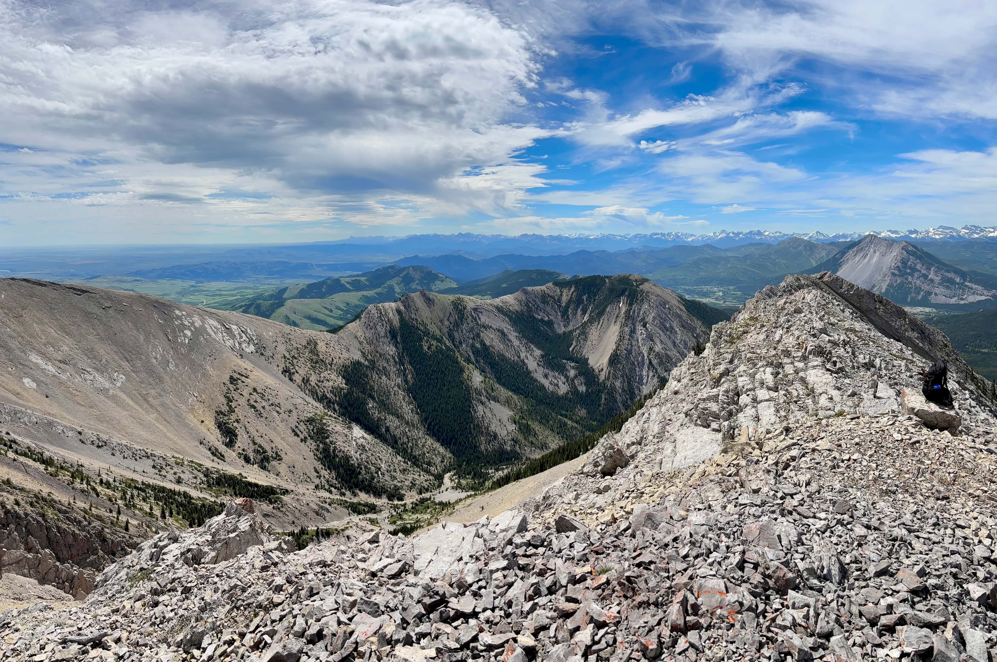
It was a partly cloudy day with minimal haze. I managed to summit early enough in the day that the forecast wind hadn’t arrived in force yet (it struck with a vengeance shortly after I returned to South Livingstone). Not surprisingly, the views were more or less the same as on South Livingstone Peak – which is to say they were excellent. After eating lunch and enjoying the vistas I returned along the same route.
The traverse between the two peaks was so enjoyable that I now can’t really imagine visiting Livingstone South Peak in the future without also visiting Morin. I used the Minotaur Skyrace’s gpx file to help guide me. It came in very handy, but (naturally) route finding was still necessary and completing the traverse involved scrambling that sometimes felt a little exposed. If those things are in your skillset I highly recommend this extension to the classic Livingstone South Peak route.
Though I used the resources linked above to plan my trip, you can check out the ones below if you’re considering climbing Morin Peak from the west:
- Dave McMurray’s May 2016 ascent (Peaks and Streams)
- Cornelius’s May 2020 ascent (Spectacular Mountains)
- All Stone Adventures’ September 2021 ascent


Hi Par,As always, your blog is very descriptive. Peak to peak going through a gully seems very scary. Nice pictures.Thanks for sharing.Bal Boora
LikeLike